| New Perspectives on Illustration is an engaging weekly series of essays by graduate illustration students at MICA, the Maryland Institute College of Art. Curators Stephanie Plunkett and Joyce K. Schiller have the pleasure of teaching a MICA course exploring the artistic and cultural underpinnings of published imagery through history, and we are pleased to present the findings of our talented students in this weekly blog.
Maps as Propaganda in the Age of Exploration by Stacey Dugan Montebello considers how early illustrated and mass produced maps have been used as a vehicle of propaganda in Europe and in America. Maps as Propaganda in the Age of Exploration By Stacey Dugan Montebello When exploring the significance of the advent of printed maps in Europe one must look to complex systems that governments used to control and censor the unprecedented amount of affordable information. The sudden ability to mass produce accurate and sensitive information was potential threat to any superpowers during the age of exploration wishing to expand their borders and/or influence. Thus many of the superpowers responded to this potential threat through censorship limiting the amount of accurate information their populace and by extension other competing nations had access to. And in response to the demand for information they created propaganda and sensationalize illustrative maps. Censorship and the strategic use of information were essential to the success of any European exploration, as exemplified by the British monarchy of their acquisition of new territory (1). The combined effect of censorship and propaganda of printed material greatly affected the use of maps in the acquisition of new territory. The British crowned is perhaps the most successful European superpower during the age of exploration because of their practices in regard to print regulation. Before anything could be mass printed in Britain, whether it was a book or an illustrated map (there were independent presses but it is very difficult to compete with license printing companies) and had to first receive approval from one of the three forms of print regulation; the Stationers’ register, licensing, or royal privileges (2). All of these were controlled directly by the crown which gave the government almost absolute power over what inevitably was printed. To get any proposed print material placed within the stationers registered “…a company agent was required to review manuscripts for potential subversive elements and then refuse or allow their publication….the practice of censorship was pervasive and effective, and…works that would have displeased the Crown or divulged secret political intelligence …. remained in manuscript.(3)” The Stationers’ register used a handwritten volume contained a list of “… what the stationers called a ‘copy’…” and it belonged to whomever had ‘entered’ it into the archive.”…Once entered, a copy could be ‘assigned’ to other members and a variety of ways. It could be sold, exchanged, mortgaged, or even subdivided into shares.” This meant that the text could be owned by one person, the illustrations by another, and the maps by the crown. This early method of copyright granted “…powerful genealogy of recorded legitimacy…” to all the printed titles archived within its pages (4). This was both a means of censorship, by deeming books unfit for print, and a means to prevent piracy and illegal printing by making sure illicit copies of registered texts were not floating around the country (5). The crown granted the stationers the right to search and seizures of both printed and manuscript books believed to be piracy or heresy. The materials could either be locked up or burned and the offending person/s imprisoned or put to death (6). Licensing was slightly different it was used mainly to create credibility for both the printed material and the printer. Readers knew that books bearing a license had been reviewed and approved by experts knowledgeable in subject matter of a given texts (7). Also there is evidence that strongly suggests the licensing either prevented or dissuaded piracy; from 1586 to 1695 licensing was almost in constant use, and when it did lapse pamphlets and piracies increased. Finally there was royal privilege, issued as “letters of patents” (8). An individual wishing to bypass the Stationers and licensing, either because their book had been rejected, deemed unfit to print or in some other way blocked or because they wanted sole control over the printed material could appeal to the Crown itself and be granted letters of patent. Any books patented in this manner were protected by what was essentially royal copyright. This is one of the earliest forms of copyright and intellectual property laws in recorded history. Extending patents to books was another way the monarchy could influence current events. “It was hoped by extending protection in this way, a new grade of tradesman would be created, wealthy and powerful within the book trade but directly dependent on crowned favor.”(9) Each of these methods of regulation impacted and shaped print culture. The Stationers’ register, was designed with censorship in mind, it allowed high-ranking government officials to wield considerable power over what went to print and what did not. Unique to the register, the way in which “copies” were recorded made it very difficult for a “better text recovered by scholars” to become published so the errors in lesser versions continued to be repeated and multiplied with every additional printing (10). Licensing had unique consequences, specifically among authors and researchers. Because a licensor could erase or amended text in order to make it more credible the”…possibility of an author’s works being permanently corrupted, [or] lost altogether” was in fact very high. Abridgments were used to censor ideas and particular authors, by subtly changing the meaning of the text a licensor could completely change the meaning of an entire work (11). But it was arguably royal privileges that held the most danger in their censorship and regulation. Because privilege books were considered property of the Crown, they bared the authority and implication of authorship through patronage of the Crown as well, so any infringement could be viewed as sedition (12). Regulation and censorship were key to continued development of print culture, and greatly influence the way maps and illustrations were used within their pages.
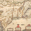
“…Most modern readers see maps and text as separate forms…, but virtually all maps are accompanied by some sort of text, and many of this period’s most important texts-particularly historical texts-were meant to be accompanied by maps… we tend to put the argument in text, and to see the map or the picture as an illustration or reflection, but maps or pictures were often the  point of entry, or the embodiment of the argument-with the text providing an illustration or justification.” (13) This ideology explains the way in which manuscript maps and accompanying journals created by skilled cartographers were guarded and how they were translated into propaganda for public consumption. In Britain there were two basic types of maps, the manuscript or true geographical maps used for circumnavigating the globe, and printed or propaganda maps used to lay claim to new territories and to influence international views about the country where the map originated. Manuscript maps were safeguarded by the Crown and the royal court for “…reasons of security and secrecy, [and] the best geographical knowledge conveyed through English drawn maps…remained in manuscript…” At the height of European seafaring exploration sudden improvements in “… land surveying and measuring, the inclusion of scales and latitude and longitude lines…, [and] the removal of speculation about the unknown…” led to the creation of charts and maps with significant scientific accuracy. As maps and charts became more accurate more information was being placed within them, place names became more accurately marked, the various routes ships had taken or had attempted to take were noted in detail, where the ships had made landfall, etc. this combined with the detailed journals also kept by the explorers laid out a step-by-step how-to guide of nautical exploration. (14) “The more the English came to know about the world through geography and cartography, the more interested they were in exploring…and establishing authority over parts of it. Therefore, the knowledge conveyed through maps was highly esteemed and was to be carefully guarded for fear of giving an advantage to other countries.” (15) This fear was not misplaced, many of the ambassadors served a dual purpose to their countries, as diplomats and as spies. In an exchange between the Spanish Crown and its Ambassador Bernardino de Mendoza “…reported… that he was ‘very hopeful of being able to obtain a chart of Frobisher’s voyage,’…” the chart in question was kept secure, for the British Crown and royal court’s use only. The implication that Spanish ambassador thought that he could obtain a copy of such a chart implies duplicity. Another prime example of the legitimacy of Britain’s fears is the suspect timing around the arrival of “… both the ‘Zu´n˜iga map’ and the ‘Velasco map’… in Spain at the same time that the English ambassadors were warning their superiors… about an impending armada assembling to attack Virginia”. These true maps and their accompanying information were guarded so heavily by the Crown that even the explorers who created them were not allowed to keep copies, or even to see them in reference after they’d turn them over to the Crown.(16) Printed maps on the other hand  were mass-produced, generously distributed, colorful and printed on cheaper and more affordable materials such as paper and often accompanied books and other printed materials as a sort of bonus.(17) These maps were used as propaganda they were specifically tailored to ensure they did not divulge sensitive information. Printed maps “…contained a number of rhetorical devices that demonstrated English sovereignty, perpetual Crown authority, and complete territorial possession and effective control, all of which were important assertions…” (18) they were far less concerned with accurately representing geographical formations than the manuscript maps, it was instead important that the images be aesthetically pleasing and “…pretentiously complete, stylistically elaborated, artistically adorned and nationalistically acceptable”. They were used to demonstrate new and augmented boundaries, to show  power through order and dominance and to instill a sense of national pride and wonderment amongst the populace. (19) “Maps displaying royal and aristocratic coats of arms, ships in the seas displaying the English ensign, distinctly Anglicized place-names, and descriptive narrative cartouches attested to English sovereignty and Crown authority over all or part of the region depicted on the map” were specifically created with international distribution in mind. (20) These elements were important to include because two of the most effective ways of obtaining new territories were occupation and prescription. By dating a map, anglicizing the names, and incorporating information and dates regarding the foundation of colonies and  holdings commercial mapmakers, at the behest of the Crown were effectively archiving a lineage of recorded legitimacy. “This made the information communicated through [printed] maps especially important in the process of expressing sovereignty in overseas territories.” (21) It was important that a claim be stated and accepted internationally because of the territory was disputed political and physical combat could break out in an attempt by other countries to seize the territory. (22) For example the explorer John Smith, went to great lengths in his maps and charts to show the long-standing, mutually beneficial relationship between the English settlers and the Native Americans. By noting the boundaries of English exploration but also having accurate and detailed information beyond that point Smith was implying that  the settlers had enough authority in the eyes of the natives to be given sensitive information (this is illustrated in the 1612 John Smith map and the 1616 John Smith maps) (23) . The British Crown censored and regulated how information via maps and charts were accessed by commissioning cosmographers, commercial mapmakers, and historians to recover and manipulate “…records, myths, and maps to advocate the creation of a global empire, secured by power over the seas that surrounded the British Isles and spread throughout the world.” (24) Towards the end of Britain’s period of colonizing, and after it acquired a vast amount of territory those in bold had used and seen many different types of land acquisition. “Physical occupation… settlement of territory not subject to the sovereignty of another Christian state; prescription, where title flows from effectual, long, continued, and undisturbed possession over a long period of time; cession, the transfer of property by treaty; or subjugation, the taking of possession from a conquered sovereign state.” They knew, as well as the other European superpowers, that the easiest, most effective and most politically defendable way to acquire territory occupied by non-Christian indigenous people was cession. (25) The power of regulation and censorship of written and specifically printed text was a powerful tool in the age of exploration and colonization. Maps in particular were “…laden with political and ideological messages…’mapmaking was one of the specialized intellectual weapons by which power could be gained, administered, [and] given legitimacy…” (26) Many of the practices employed were so effective that they continue to be used to this day. Nationalistic textual regulation changes the behaviors and thoughts of the subject to it now just as it did during the advent of the printing. (27)
End Notes 1. MacMillan, Ken. “Sovereignty “More Plainly Described”: Early English Maps of North America, 1580–1625.” Journal of British Studies 42, no. Vol. 42, No. 4 (October 2003), 422-423. 2. Johns, Adrian. The Nature of the Book: Print and Knowledge in the Making. Chicago, Ill.: University of Chicago Press, 1998. 263 3. MacMillan, Ken. “Sovereignty “More Plainly Described”: Early English Maps of North America, 1580–1625.” Journal of British Studies 42, no. Vol. 42, No. 4 (October 2003), 430-431. 4. Johns, Adrian. The Nature of the Book: Print and Knowledge in the Making. Chicago, Ill.: University of Chicago Press, 1998, 213-214. 5. Johns, Adrian. The Nature of the Book: Print and Knowledge in the Making. Chicago, Ill.: University of Chicago Press, 1998. 191. 6. Ibid, 234-236. 7. Ibid, 239-240. 8. Johns, Adrian. The Nature of the Book: Print and Knowledge in the Making. Chicago, Ill.: University of Chicago Press, 1998. 249. 9. Ibid, 248 – 250. 13. Sherman, William. “Putting the British Seas on the Map: John Dee’s Imperial Cartography .” Cartographica: The International Journal for Geographic Information and Geovisualization 35, no. 3-4 (1998): 8. 14. MacMillan, Ken. “Sovereignty “More Plainly Described”: Early English Maps of North America, 1580–1625.” Journal of British Studies 42, no. Vol. 42, No. 4 (October 2003), 415-420. 15. MacMillan, Ken. “Sovereignty “More Plainly Described”: Early English Maps of North America, 1580–1625.” Journal of British Studies 42, no. Vol. 42, No. 4 (October 2003), 422-423. 16. Ibid, 423-425. 17.Ibid, 431. 18. 19. Sherman, William. “Putting the British Seas on the Map: John Dee’s Imperial Cartography .” Cartographica: The International Journal for Geographic Information and Geovisualization 35, no. 3-4 (1998): 3. 20. MacMillan, 414. 21. Ibid, 415. 23. Ibid, 440. 24. Sherman, William. “Putting the British Seas on the Map: John Dee’s Imperial Cartography .” Cartographica: The International Journal for Geographic Information and Geovisualization 35, no. 3-4 (1998): 1-2. 25. MacMillan, Ken. “Sovereignty “More Plainly Described”: Early English Maps of North America, 1580–1625.” Journal of British Studies 42, no. Vol. 42, No. 4 (October 2003), 428. 26. MacMillan, Ken. “Sovereignty “More Plainly Described”: Early English Maps of North America, 1580–1625.” Journal of British Studies 42, no. Vol. 42, No. 4 (October 2003), 413. 27. All images were taken from : Gloria Gilda Deak, Picturing America 1497-1899 Volume II: Illustrations
|